| |
![]()
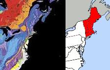
 New England
The tiny New England states are grouped at the end of what will become increasingly a peninsula of land, due to the widening of the St. Lawrence Seaway and the melting poles. The land is rocky, and will rise some 450 feet by our estimate above the current level due to the land being freed from its current connections during this continental rip. During rotation stoppage, the Atlantic will be stretched, causing land along the southern East Coast of the US and islands such as Scotland and Ireland to drop some 150 feet below the waves. But at the combined ripping of the St. Lawrence Seaway and Atlantic rift, this peninsula of land which is currently called the New England states will be allowed to find its level based on the natural relative gravity of the land. The land will bob up, some 450 feet above the current level. Nevertheless, due to polar melt to occur over the two years following the shift, this rise will be lost and the coastline actually going under the waves some 200-250 feet beyond the current beach level. Thus, those with homes 250 feet above the coastline might find themselves on the beach. However, to be safe during the shift, our precautions of being 200 feet above sealevel and 100 miles inland should apply. Sloshing in the Atlantic, and unpredictable water movement into and out of the St. Lawrence Seaway, will result in terrifying moments for those any nearer to the coast. Return to the coastline after some days have passed, and the water seems to have settled into tides that are predictable.
ZetaTalk ™
We have stated that the toggle point where land will bounce up during the pole shift, for the New England states, and be pulled down prior to or during the pole shift, for the southern states, is Pennsylvania. We have stated that the bounce up should be prorated from Montreal to the mouth of the Seaway. Note that across from Montreal there is a rock strata emerging and running south and down into the Appalachian Mountains. Lake Champlain situated between the Green Mountains of Vermont and the Adirondack Mountains of New York is along this rock strata. This is a rip point, as we have described, where the New England area will bounce up vs being held down. This rock strata runs directly south to where Manhattan Island touches the mainland. Thus, our statement that the New England region would get the bounce. Obviously, there is not going to be a cliff at this rock strata boundary, 450 feet in height. The land will slant. To be on the safe side, assume all of Maine to have the full bounce, and prorate your bounce from there to the western edge of the New England states.
ZetaTalk ™ 2010
Note East Coast Migration commentary.
Note Boston Area commentary.
