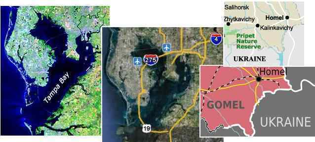
Florida Howl
First we had the Kiev trumpets and now it seems these sounds are emerging elsewhere around the world. The Kiev trumpets
were featured in Issue 255 of this newsletter on August 21, 2011, and were caused, per the Zetas, by a vibrating dam
amplifying the vibration in the reservoir above Kiev. These tones were harmonious, truly akin to music. But numerous videos
from Florida and elsewhere in central Europe have the vibration sound as a howl, a roar, a buzz, or a horn. As mentioned on
a Pole Shift ning blog these sounds are also being heard in Illinois, Sweden, and Russia. Compare the recordings made in
Tampa Bay Florida to recordings made in Homel, Belarus and Kiev in the Ukraine. These are variously a howl, a horn, and
multi-tonal trumpets.
AUDIO: http://www.zetatalk3.com/ning/03spTampa.mp3
VIDEO: http://www.youtube.com/watch?feature=player_embedded&v=v5YjbQFIIVs
AUDIO: http://www.zetatalk4.com/ning/03spBelarus.mp3
VIDEO: http://www.youtube.com/watch?feature=player_embedded&v=zJaGOLL_41g
AUDIO: http://www.zetatalk5.com/ning/03spKiev.mp3
VIDEO: http://www.youtube.com/watch?feature=player_embedded&v=vMfhKZV2P9Y
The river passing by Homel, Belarus is broad and deep, like a reservoir, and Tampa Bay itself is an enclosed body of water.
But why the difference in sound? The Zetas explain.
ZetaTalk Explanation 8/20/2011: As we explained for the Kiev trumpets, when an enclosed body of water rests on
vibrating ground, music can be produced. But the variety of sounds that vibrating ground can produce in a stretch
zone is not always musical. The fact that the ground is vibrating is reported by witnesses, who state they can feel the
vibration in the ground. Yet the official explanation, at a loss to explain the current Earth changes, involves the
atmosphere. Somehow, it is the wind. In Kiev the reservoir dam amplified the vibrations, so the reservoir was
singing. But where a broad expanse of ground is vibrating, such as the Florida recordings indicate, so many tones
are produced that the result is a howl.
Imagine a choir, which normally sings in harmony, each singing a particular note. Imagine the choir members each
just making a noise, not a harmonious note, so that a hundred voices are merging into what would seem to be a
howl. This is Florida. The entire state is a stretch zone, being pulled down and toward the center of the Atlantic by
the spreading Atlantic, but likewise being pulled side to side by plate movement in the Caribbean Plate as the S
American rolls progresses. This creates vibration, as the rock resists being pulled apart or bent - first a tug, then a
bounce back. During the ball game, when the Florida howl could be heard as background noise during the
broadcast, the bowl of the stadium was acting like the enclosed air in a drum, amplifying the sound coming from the
bay area itself.
Bending Plates
During the 7 of 10 plate movements, there are subduction points, where one plate is subducting under another, or stretch
zone points, where the rock layers are pulled apart, and there are points where a plate bends to accommodate a tilt in the
plate. The sinking of the Sunda Plate, which holds Indonesia, etc. is an example of a bending plate. The Sunda Plate, often
called the tongue of the Eurasian Plate, acts as an extension of the Eurasian Plate, but bends down as the tongue is shoved
under the curve below Sumatra and Java. This bending creates a sinkhole belt in southern China, as detailed in Issue 190 of
this newsletter, and has lately created a spate of cracks in nearby northern Thailand. This is the bending point during the
dropping of the Sunda Plate.
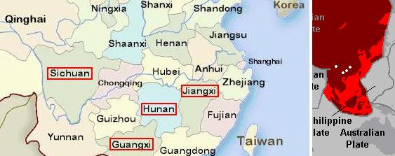
- Northern Province Alarmed by Land Cracks
August 26, 2011
http://www.tannetwork.tv/tan/ViewData.aspx?DataID=1047182
- Nan Province and the Mineral Resources Department are rushing to deal with large cracks that have
appeared in the land in Pua District. In an initial probe, at least 10 cracks of 500 meter-long, 10 meters wide,
and 2 meters in depth land cracks were reported.
As the Atlantic rips open, coastal areas on both sides of the North Atlantic are pulled down. For the US, the bend point is in
Pennsylvania, because the land to the north gets a boost as the Seaway rips open, bouncing up in elevation, while the land to
the south is pulled down. Eventually, Florida loses 150 feet in elevation. So what happens in Pennsylvania? Beyond being
noted for a huge number of sinkholes in recent years, they have had a rash of collapsing buildings in Philadelphia, all at once.
For the East Coast, Pennsylvania is the bend point.
- 2 Freed from Fallen House, 3rd Collapse of Week
August 20, 2011
http://www.philly.com/philly/news/pennsylvania/128115023.html
- In the third building collapse this week, two construction workers were injured when a North Philadelphia
rowhouse crumbled, temporarily trapping them inside. The incident came three days after two other buildings
crumbled in other parts of the city. A wall in a Frankford church at Griscom and Orthodox streets collapsed.
That night, part of a three-story apartment building collapsed on 15th Street near Clymer in South
Philadelphia, smashing a car parked curbside.
-
- 3 Injured in Building Collapse in South Philadelphia
August 23, 2011
http://abclocal.go.com/wpvi/story?section=news/local&id=8319630
- Two workers are hospitalized after a 3-story building collapsed in the Graduate Hospital section of South
Philadelphia.
Proof that the southeast coast of the US gets pulled down during a passage of Planet X lies under the waves near the
Bahamas. The sunken land shelf off-shore from the US East Coast also shows tree stumps and even the bodies of buffalo
under the waves. The Caribbean once allowed access between Florida and Venezuela, a land bridge.
- Pre-Ice Age Complex Found Off Bahamas Coast
August 17, 2011
http://www.edgarcayce.org/edgar_cayce/news.aspx?id=5170
- Researchers have investigated an underwater site with what appears to be the remains of a collapsed
multi-room building. The building foundation has manmade mitered limestone corners and other debris inside
the outer walls. A highly developed culture once lived off the coast of the Bahamas and operated throughout
the region.
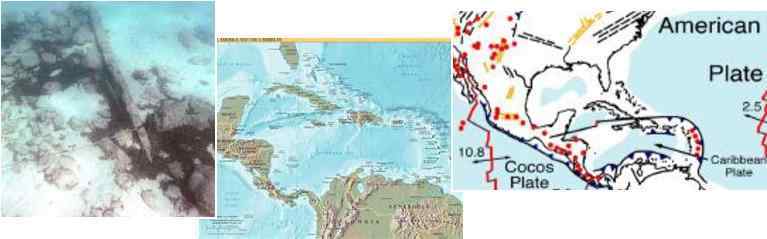
ZetaTalk Comment 8/27/2011: It is known that land off the East Coast of the US, and in the Caribbean, was once
above the waves. The remains of forests can be seen beneath the waves, roads paved with carefully cut stones, and
the clear outline of where rivers cut through the previous coastal area. It is clear from the ruins in Central and S
America that civilizations existed in the past, and for reasons mankind cannot fathom, disappeared. The reason man
struggles with this is that denial is much more comfortable. To imaging cataclysms that could drop the land beneath
civilizations is too horrific to contemplate.
Across the Atlantic, off shore from the UK and Norway, there also is land just under the waves which was once above the
waves, The land shelf can be seen in satellite images. Recently there was a rare oil leak in the North Sea, for no ostensible
reason. Per the Zetas, this is a bend point, as these coastal regions are being pulled down as the Atlantic spreads.
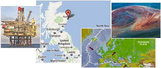
- Shell North Sea Pipeline Leak Reduced to a Trickle
August 16, 2011
http://www.reuters.com/article/2011/08/16/us-shell-leak-idUSTRE77F19L20110816
- Shell said oil seepage was continuing from a relief valve next to the main leak, dismissing reports of a second
leak. The spill on Shell's Gannet field, which it co-owns with Exxon Mobil Corp and which lies 180 km off the
Scottish port of Aberdeen, had been leaking for two days before authorities or Shell spoke up.
ZetaTalk Comment 8/20/2011: This region is neither a plate border nor fault line. But it does lie in the area destined
to be pulled down during the plate movements preceding the pole shift and certainly during the pole shift itself. We
have predicted that Ireland, Scotland, and Wales will be pulled down to a greater extent than England herself. What
happens when plates are bent in this way? Rock layers bend, and snap, and certainly destabilize anything like an oil
pipeline that expects a smooth firm surface. A pipeline that lacks support will itself fracture, fitting pulling apart,
and there you have a leak. More of this will certainly occur.
Luzon Sinks
During the 7 of 10 scenarios, and where the sinking of the Sunda Plate holding Indonesia began on December 23, 2011, the
northern island of the Philippines remained untouched. Luzon lies not on the Sunda Plate, but on the Philippine Plate, and thus
the difference. Sinking reports up until April 24, 2011 showed that Luzon had not had sinking up until that date, and as
reported in Issue 249 of this newsletter on July 10, 2011, even when typhoon Falcon passed, northern Luzon remained
untouched. Now matters have changed! The Philippine Plate, stuck and prevented from dropping for many months as, per
the Zetas, it had become jammed, is now apparently on the move! Northern Luzon is sinking. Why else would Falcon leave
this area untouched, when Mina now devastates it with flooding up to 26 feet in Cagayan? These are coastal cities, all, thus
subject to inundation from the sea or slow draining rivers due to scarce difference in sea level elevation, all signs of sinking.
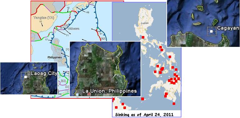
- 25 Families Evacuate Homes in Laoag
August 28, 2011
http://www.abs-cbnnews.com/nation/regions/08/28/11/25-families-evacuate-homes-laoag
- Twenty-five families evacuated from Barangay 29 in Laoag City early Sunday morning as flood waters
entered their homes.
-
- 'Mina' Affects 15,000 Families in Cagayan
August 27, 2011
http://www.abs-cbnnews.com/nation/regions/08/27/11/mina-affects-15000-families-cagayan
- Typhoon "Mina" continues to batter Cagayan province, affecting more than 15,000 families in 15
municipalities. The river's water level has already reached 8.5 meters, causing water to overflow in 6
provincial bridges.
-
- 700 Families in La Union Flee their Homes
August 28, 2011
http://www.abs-cbnnews.com/nation/regions/08/27/11/700-families-la-union-flee-their-homes
- More than 700 families in La Union were evacuated after raging floods submerged several houses.
DC Panic
The United States has been spared the Planet X incited Earth changes until recently, due to the torque in the wobble. Since
2003, when Planet X came into the inner solar system, the twisting wobble has eased the pressure on the West Coast of the
US, so that as the rest of the world has experienced increasing quakes, the US has had, relatively speaking, a vacation. The
Zetas provided this explanation just after the December 26, 2004 tsunami quake in Sumatra.
ZetaTalk Explanation 1/23/2005: Put your hand on the N. Pole of the globe, twisting to the right as though turning
the cap off a jar. Put your other hand on the S. Pole of the globe, twisting to the left as you open the jar, in this case
the Earth, her plates coming apart. You not only pop the Indio/Australian plate lose and plunge the Pacific and
Philippine plates under Asia, you relieve stress along the entire N. American continent!
Vacation time is over. Because of the bow stress on the N American Plate, more than sinkholes and hums in the stretch
zones will be occurring. Almost simultaneously, a rare 5.3 occurred in Colorado and the East Coast, including the
Washington DC area, was rattled by a 5.8 quake.
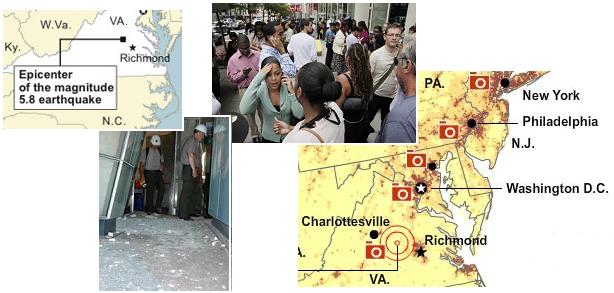
- Why Virginia Quake Shook Entire Coast
August 25, 2011
http://news.yahoo.com/why-virginia-quake-shook-entire-coast-205833903.html
- The shaking was felt over such a large area - as far south as Atlanta and as far north as Ontario, according to
eyewitness reports - largely because the eastern part of the North American continent is different than the
West Coast, where quakes are more common. The epicenter was 5 miles from Mineral, Va., and 84 miles away
from Washington, D.C. Despite the distance, the Pentagon, the Capitol and other buildings were evacuated.
Faults that rupture east of the Rockies usually create quakes felt over more than 10 times the area than those
west of the mountains, according to the USGS.
-
- Earthquake Shows Difficulty of Evacuation from DC
August 25, 2011
http://news.yahoo.com/earthquake-shows-difficulty-evacuation-dc-074246637.html
- The nation's capital has prepared for emergencies with sleek communication systems, intelligence fusion
centers and chemical detention centers at train stations. Traffic was snarled for miles in downtown
Washington as employers released workers early at the same time thousands of commuters tried to drive home
or cram onto buses and trains already overloaded and slowed by speed restrictions because of the quake.
Per the Zetas, those who have enjoyed a vacation from the quakes the rest of the world was experiencing had better gird up
their loins, as its only going to get worse.
ZetaTalk Lecture 8/27/2011: These two quite minor quakes in the US - what has been called a 5.8 in DC and a 5.3 in
Colorado - are merely a hint of what is to come for the US as the time of the New Madrid adjustment approaches.
We have requested that we not be asked about every minor earthquake as this will soon become almost a daily affair
for the North American continent. Have our predictions not been given? Have they changed, simply because the
cups in your cupboard jiggled? Stretch zones are permeated with soft soil subject to liquefaction, as by their nature
they are rock layers pulled apart, so must be filled with something. Water is most often the substance that fills the
voids and thus liquefaction is facilitated. It is well known that quakes along the West Coast affect an area the
fraction of the size of the area affected on the East Coast, due to liquefaction factors. Get used to the jiggle, and get
some perspective!
Indeed, USGS documentation shows extremes due to liquefaction between the West Coast and the East Coast. During the
quakes leading up to the big New Madrid adjustment, there will be lots of jiggling in the eastern half of the US. Pack the
good china away and put a big pillow on the floor in front of the TV set and learn to live with it!
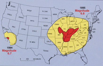
SOURCE: USGS
- http://quake.wr.usgs.gov/prepare/factsheets/NewMadrid/
- Earthquakes in the central or eastern United States affect much larger areas than earthquakes of similar
magnitude in the western United States. For example, the San Francisco, California, earthquake of 1906
(magnitude 7.8) was felt 350 miles away in the middle of Nevada, whereas the New Madrid earthquake of
December 1811 (magnitude 8.0) rang church bells in Boston, Massachusetts, 1,000 miles away. Differences in
geology east and west of the Rocky Mountains cause this strong contrast. [And more recently] earthquakes of
similar magnitude-the 1895 Charleston, Missouri, earthquake in the New Madrid seismic zone and the 1994
Northridge, California, earthquake, [showed similar effects].
-
- http://edition.cnn.com/2005/TECH/science/06/22/new.madrid.quake/
- The [quake] in 1968, centered in southeastern Illinois near the confluence of the Tennessee and Ohio rivers,
caused moderate damage, but it was felt across 23 states - as far as the Carolinas - and into Canada.
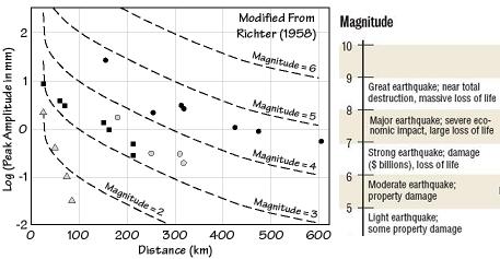
Normally, magnitude can be determined by a combination of the distance and the force of the jolt, as both are taken into
consideration when determining magnitude. But where there is liquefaction, such as in the mud in the Mississippi Valley and
all the rock layers pulled like taffy in the eastern half of the US, the distance measure is skewed.
You received this Newsletter because you subscribed to the ZetaTalk Newsletter service. If undesired, you can quickly Unsubscribe.
|