St. Vincent Sinks
The sinking of the Caribbean has started on the island of St. Vincent.
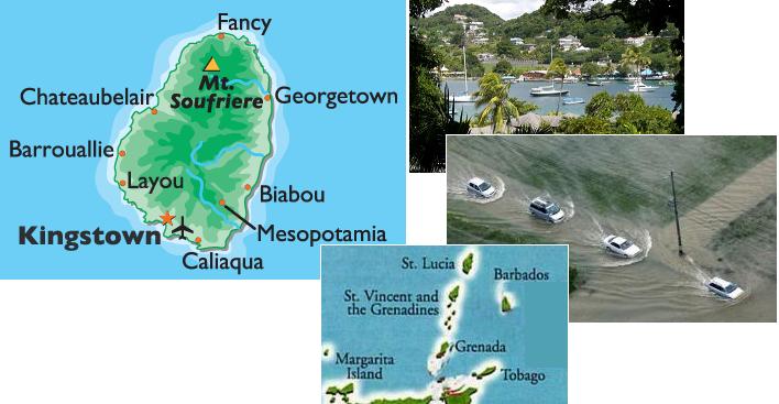
The chain of islands from Barbados to Tobago is expected to be the most gravely affected by the sinking of the Caribbean
Plate. St. Vincent is in the center of this chain.
ZetaTalk Prediction 1/15/2011: Islands just to the north of S America will be affected the most such that Barbados to
Tobago may sink entirely except for the highest points, losing several hundred feet in elevation, and Trinidad will be
torn apart in addition to sinking as it rides on the plate border.
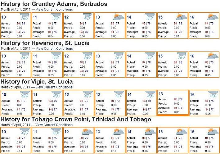
Flooding was reported on April 12, 2011 on St. Vincent and several of its neighboring islands. Yet none of these islands had
more than an inch of measurable precipitation for the entire week.
- Situation Report 1 -Flood Event in Barbados, Grenada and St. Vincent and the Grenadines
April 12, 2011
http://reliefweb.int/node/395952
- Barbados: The Department of Emergency Management (DEM) reported a flash flood event mainly in the
northern parishes of St. Peter and St. Lucy. Flood waters rose marooning persons in their homes and
damaging furnishings and vehicles in the areas of Rose Hill, Collerton, and Gills Terrace and St. Peter.
Grenada: The National Disaster Management Agency (NaDMA) in Grenada has reported flooding and small
landslides in Gouyave, St. John. St. Vincent and the Grenadines: The National Emergency Management
Organisation (NEMO) reported early this morning that landslides had blocked the Windward highway at
several points from Biabou up to Sandy Bay. The Mt. Young River, Sandy Bay River and other rivers in
Georgetown had overflowed their banks and flooded a number of houses.
-
- St.Vincent receives battering from heavy rains over night
April 12, 2011
http://www.whatsupcaribbean.com/index.php?
- Heavy rains overnight lashed a number of Caribbean neighbours causing extensive damages in some cases. In
Grenada there were flooding and land slides reported. In Barbados in some areas there were also flooding.
Over in St.Vincent bridges were damged, houses washed away and some severely damaged.
There was no measurable precipitation! No high tides or storms to account for the flooding that occurred. The sinking in the
Caribbean has begun!
Giant Whirlpools
The Zetas have often predicted an increase in ocean whirlpools, as a result of the increasing Earth wobble.
ZetaTalk Explanation 2/18/2005: Why would these not form, in the oceans, as a result of increasing wobble,
especially as warm and cold air will mix during this sloshing, adding to the formation of tornadoes in the water, the
whirlpool effect. During a violent wobble the Earth lurches quickly, as has been noted at times by startled observers
seeing the Moon or constellations move too quickly or the Sun hovering too long at certain times of day. Those
carefully observing and recording such things are astonished, sensing they are actually observing the wobble, no
longer theoretical but palpable.
A giant whirlpool appeared off coast of Japan during the recent great tsunami, as noted in Issue 233 of this newsletter on
March 20, 2011. Now a pair of them have suddenly appeared off the northern coast of S America.
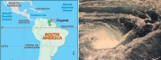
- Scientists Puzzled by Giant Whirlpools that have Appeared in the Atlantic Ocean
April 12, 2011
http://theextinctionprotocol.wordpress.com/2011/04/12/scientists-puzzled-by-giant-whirlpools
- U.S. scientists discovered two giant whirlpools in the Atlantic Ocean, off the coast of Guyana and Suriname. It
became a sensational discovery because this part of the ocean has been studied thoroughly, and no one
expected anything like that to appear in the area. More importantly, no one can understand where the
whirlpools came from and what surprises they may bring to people. According to Brazilian scientist Guilherme
Castellane, the two funnels are approximately 400 kilometers in diameter. Until now, these were not known
on Earth.
Per the Zetas, the dual whirlpools off coast of S America are in fact caused by plate movement, or rather plate tugging, a sign
of the pending S America roll!
ZetaTalk Explanation 4/23/2011: As the Earth wobble becomes stronger and more violent, the forces moving air and
water masses will increase, temperature mixing will increase, and certainly the force of water or air will create
different wind speeds or different current flow rates. Giant whirlpools appeared off the coast of Japan during the
recent tsunami, and have recently appeared off the coast of Guyana and Suriname off the north coast of S America.
Why would this region generate giant whirlpools? The Caribbean Plate is being pushed to the west, as the roll of S
America gains momentum. This leaves a void just to the east of the Caribbean Plate, temporarily filled by dropping
the floor of the S American Plate in that area, flattening the ocean floor between Guyana and Suriname and the
Atlantic Rift in the center of the Atlantic. Ripping apart of the Atlantic Rift has not yet begun there. Water rushes in
to bring the ocean to its level, and whirlpools develop. This is yet more evidence that the S American Plate is on the
move!
Weather extremes are also evident, also due to the increased violence of the Earth wobble. If the dual giant whirlpools in the
Atlantic off the coast of S America hit the press on April 12, 2011, this was followed closely by a spate of tornadoes in the
US, historically unparalleled in number. As of Saturday, April 16, 2011 some 241 tornadoes had been counted across 14
states.
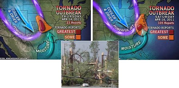
- Death Toll Rises as Tornadoes Ransack Carolinas
April 16, 2011
http://www.accuweather.com/blogs/news/story/48478/tornado-outbreak-death-destruc.asp
- There have been more than 241 reports of tornadoes from the Plains into the Midwest, Deep South and
Carolinas. Most of the 113 reports from Friday alone came out of Mississippi and Alabama. Thursday's
reports were focused largely in eastern Oklahoma, though there were a few in Kansas, northeastern Texas and
Alabama. Saturday's total number of tornado reports was up to 105 with the majority of them occurring in
North Carolina.
Lingering Floods
The Thailand neck, on the peninsula, had lots of rain in late March, which can disguise sinking, but now that the weeks have
passed those areas that sank can be discerned. Surat Thani is in an area predicted by the Zetas to lose up to 40 feet in
elevation. Phunphin at center is 9 meters (27 feet) in elevation, and is under water that is refusing to drain.
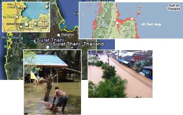
- Three Villages in Surat Thani Province Still Under Deep Floodwaters
April 15, 2011
http://www.mcot.net/cfcustom/cache_page/195737.html
- Three villages in Thailand's flood-ravaged southern province of Surat Thani are still under at least a metre of
floodwater, forcing local residents to sleep on the roadways and in temporary relief centres. Phunphin district
officer said three villages in his charge remain submerged after nearly three weeks of flooding. Small vehicles
cannot travel there and villagers must travel by boat.
Timur overall has a high elevation but does have some areas on the south coast which would be under water at the 80 foot
drop in elevation predicted by the Zetas. There, where the river empties into the Timur Sea on the south coast of Belu
Regency, is such a location. The flooding that enveloped this region at the end of March is still with them two weeks later, on
April 15, 2011, so that the residents can only travel by boat!
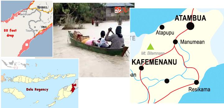
- E. Nusatenggara Floods Force Mass Evacuation
March 31, 2011
http://www.thejakartapost.com/news/2011/03/31/e-nusatenggara-floods
- More than 1,447 people have left their homes to avoid a flood that has swept through West Malaka in Belu
regency, East Nusa Tenggara. The figure is expected to increase as evacuees from three flood-affected
villages of Mota`Ain, Sikun and Fofoe had not yet been counted. The only way to reach the villages now is by
boat.
-
- Sikun Village Residents are Forced to Use Canoes
April 15, 2011
http://berita.liputan6.com/daerah/201104/329691/korban_banjir_belu_terisolasi
- Floods in West Malaka, Belu, East Nusa Tenggara. Roads in the village of Sikun already looks like a river. The
pool of water never receded. A number of military and police personnel to evacuate residents to a place of
refuge because the water level continues to grow.
The Lamongan region has been in this newsletter as one of the spots sinking to the 80 foot level already, in Issue 236.
Certainly Lamongan itself averages 6 meters in elevation, which is an 18 foot drop. The sinking is not admitted, but the fact
that students have had to use a boat for the past two months to get to school has just hit the press. One must read between
the lines during the cover-up.
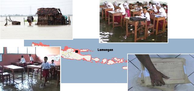
- Besieged Flood, Trustees Boat Wear
April 20, 2011
http://regional.kompas.com/read/2011/04/20/09455543/Dikepung.Banjir.Pengawas.Pakai.Perahu
- Lamongan. Puddle in the school already lasted two months. Especially during school exams to prepare a boat
to pick up the controller and the UN committee. For students already set up five boats that can be rowed
themselves to school students. Since two months they use the boat.
Hanoi in northern Viet Nam is in the zone predicted by the Zetas to lose 20 feet in elevation. Hanoi has an elevation of 6-10
meters, per Google Earth, or 24-30 feet. But the sinking process has affected the stability of the ground there. Sinking of the
ground has occurred, so buildings do not have a stable footing. The residents are in panic.
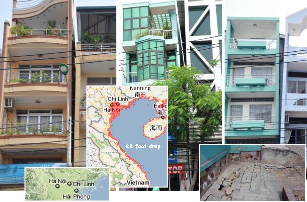
- Leaning Houses in Hanoi have Caused Panic in HCM City, Vietnam
April 15, 2011
http://english.vietnamnet.vn/en/vietnam-in-photos/7091/leaning-houses-in-hanoi--hcm-city.html
- The recent collapse of a five-storied building in Hanoi has caused panic since a number of other buildings in
the capital suffer tilts due to subsidence and show signs of possible collapse.
Planet X Twist
The Zetas have been hinting in the past few months that we would have increased signs in the skies, all without revealing what
these signs might be. As always, they want to surprise the establishment, hoping to dislodge the cover-up in this way. There
have always been on occasion videos and photos of bright orbs around the Sun, known as Moon Swirl orbs as the light from
the Sun funnels down the long tube formed by the swirling moons to shine like a flashlight toward Earth. These Moon Swirl
orbs are seen naked eye as well as captured on film, as noted in Issue 59 on January 20, 2008 of this newsletter. Monster
Sun's have returned also, those large, pale orbs as large as the Sun denoting the location of Planet X, as noted in Issue 232
on March 13, 2011 of this newsletter. But on the Coast to Coast website a photo of a Monster Sun appeared where the
monster was in the wrong place to be Planet X! Per the Zetas, this is from a Moon Swirl, and we can expect more of this.

ZetaTalk Explanation 4/16/2011: If Planet X is at the 4 o'clock position when seen from the northern hemisphere,
why is this Monster Sun appearing above the Sun? The same bending light phenomena that causes a pale dim
monster orb to present can occur with the light from a Moon Swirl as well. Since the tail of Planet X is pointing more
directly at Earth, hosed out from the magnetic N Pole of Planet X which is turning toward the Earth, the Moon
Swirls as tubes will be funneling light in this manner more frequently.
The Zetas obviously were aware that Planet X would twist to hose its tail more directly at the Earth, a fact which was
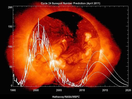
mentioned just last week in Issue 237 of this newsletter to be causing neon blue swirls. A sudden uptick in sunspots is
another consequence of this twist. This was noted on a NOAA chart, a sudden doubling of the sunspot count. Sunspots
during this solar cycle have been remarkably dearth, despite NASA's hopes that they could blame evidence of Planet X in
the vicinity on the Sun. This recent NASA chart shows the dramatic lack of sunspots this cycle. But why would the count
suddenly double? Per the Zetas, this is related to the Planet X twist.
ZetaTalk Explanation 4/16/2011: Sunspots have been dearth, as noted by human scientists this solar cycle. It is hardly
surprising that their number would increase, as Planet X or no Planet X, this is the solar maximum time frame.
Sunspots are inherently magnetic, as human scientists are aware. Sunspots had been suppressed up until recently by
the magnetic S Pole of Planet X, which acts as a magneton intake. Planet X had been pointing its S Pole toward the
Sun, its N Pole pointing outward in the direction of Earth.
Since Earth was always skirting backwards in its orbit, to escape Planet X coming at it in its retrograde orbit, Earth
was not directly in the line of blast from the magnetic N Pole of Planet X. But the grip Planet X has on the Earth,
Venus, and the Dark Twin has been tightening lately, as Planet X is outbound and is closing the gap. Looking at this
drama from outer space with the N Pole of Earth topside, one would have seen Planet X slightly to the right with
Earth, Venus and the Dark Twin clustered to the left. For reasons too complicated to explain, due to the approach of
the April Trimester which arrives on April 20, Planet X is pointing its N Pole more to the left, toward the cluster of
planets. This skews Planet X so its S Pole is not pointing directly at the Sun, no longer acting as a direct intake for
magnetons from the Sun. Thus, sunspots are again appearing on the surface of the Sun.
Horseshoe Asteroid
If signs in the skies are anticipated by NASA, who surely read ZetaTalk regularly, what can a nervous cover-up do? The tail
of Planet X is filled with debris, so fireballs will increase, and those Moon Swirls, during to point toward the Earth, creating
bright orbs around the Sun visible to the public. Might the moons themselves be visible to man too? Horrors! How to explain
this! The Zetas have long stated that the establishment would claim asteroid swarms when the moons became visible, and this
excuse is not being mustered forth!
ZetaTalk Prediction 11/14/2009: Earlier such debris was called space junk, until this excuse was overused and the
public beginning to raise a suspicious eyebrow. Then the increase in fireballs was noted by the public. We have often
stated that the debris in Planet X, the moon swirls, are likely to be called an asteroid swarm when they become
noticed. They are getting the public ready for such an excuse.
Now we have an announcement from NASA that asteroids can linger around Earth, in what they call a horseshoe orbit.
- Earth Finds New Companion as Giant Aasteroid Joins its Path Around the Sun
April 7, 2011
http://www.dailymail.co.uk/sciencetech/article-1374054/Earth-joined-giant-asteroid-sun
- Earth has found a new companion that has joined its orbit around the sun, scientists have revealed. It may not
have the most romantic of names, but Asteroid 2010 SO16 could pursue Earth for anywhere between the next
120,000 to a million years. And at a few hundred metres across, it is the largest space rock ever discovered so
close to earth.
Look up in the sky! Is that a bird? A plane? Oh, its Superman a horseshoe orbit asteroid swarm!
ZetaTalk Explanation 4/16/2011: There is no such asteroid orbit to and fro to the side of Earth, as might be suspected
since asteroid orbits have been studied for decades by the thousands and this is being first announced. Why the
announcement at this time? Because the debris in the tail of Planet X is increasing, and they need more excuses. We
predicted that asteroid swarms would be one such excuse, and this is a variant.
You received this Newsletter because you subscribed to the ZetaTalk Newsletter service. If undesired, you can quickly Unsubscribe.
|