|
New York Crumble
Last December the Zetas were asked about numerous disasters in
the New York City area, and stated it was a combination of 4
fault lines touching there and the long run of rock ripping that
releaes Methane. The underground burning of this Methane had
crumbled the rock in many places.
ZetaTalk Explanation
12/31/20223: For
the past couple years the junction of several N American fault
lines at the New York City area has stressed that region.
Bright red on the Methane emissions charts, and bright red on
the CO smoke from burning Methane underground. What does this
do to the upper rock strata where several densely populated
cities are located? The upper rock strata is crumbling and at
the slightest tremor could open crevasses or cause landslides
or shift the surface into a tilt. This is a mega disaster
waiting for New York City.
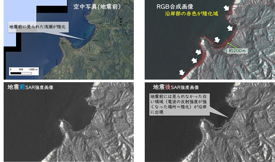
Zetas Right Again, as after stating that a “mega disaster” was
waiting for New York City, not a week later Roosevelt Island
began to crumble, causing booms and grid outages and shaking.
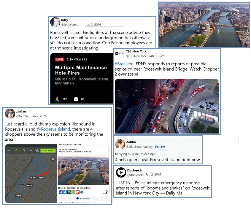
- Emergency Response Swings into Action
after Reports of 'three Booms and Shakes' on New York City's
Roosevelt Island
January2, 2024
https://www.dailymail.co.uk/news/article-12918859/Emergency-response
- Emergency responders have
'reported feeling vibrations' in both Roosevelt Island,
Manhattan and Queens and allegedly requested that energy
firm Con Edison 'address power outages at several
buildings'.
ZetaTalk Confirmation
1/2/2024: What
were we saying just 7 days ago? “This is a mega disaster
waiting for New York City.” The stress at the top of the SE
Portion will be intense in the final stretch. The New Madrid
Fault Line virtually merges with the Seaway at its exit, so
both great rifts in the N American Continent are waggling back
and forth at this juncture. Add to that is the effect of
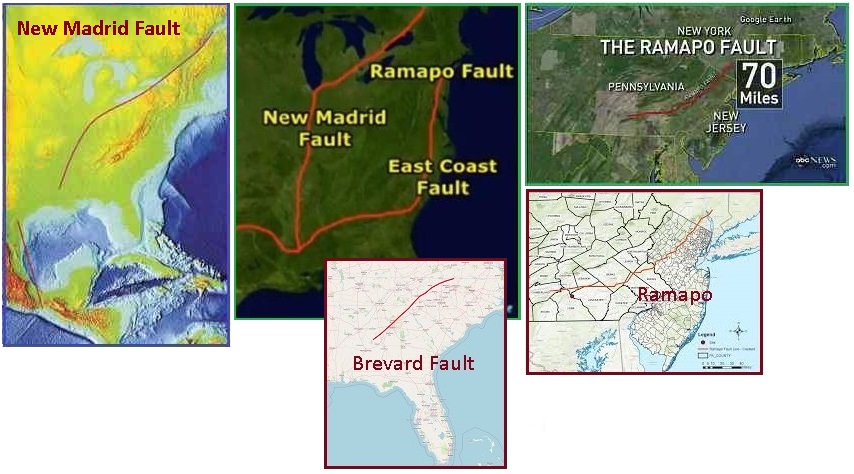
several other fault lines that merge in the New York City area
- the East Coast fault line, the Ramapo, and the fault line up
along the Appalachia Mountain chain. A mega disaster for New
York City.
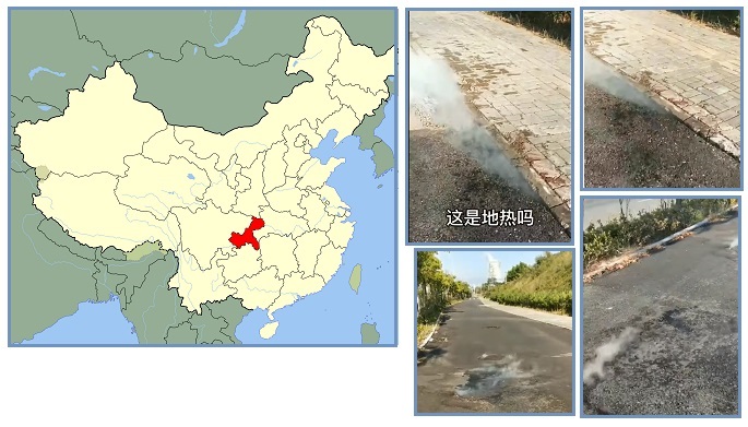
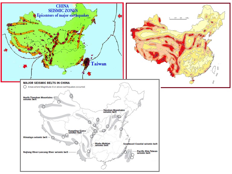
New York City is not alone as Beijing and much of China has
suffered for over a year with Methane emissions and underground
burning. China had melting roads due
to this problem in 2022, and now in 2023 is afflicted with fires
and explosions.
- Explosions Everywhere in China? Stores
and Chemical Plants Ablaze, Worsening the Economic Woes
January 3, 2024
https://www.youtube.com/watch?v=8xCNd2l42mI
- Recently, China has been plagued
by a series of fires, following reports of heating pipe
bursts and several fire incidents. The country is
witnessing a surge in major fire accidents, with frequent
and widespread occurrences burning through various
regions.
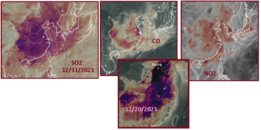
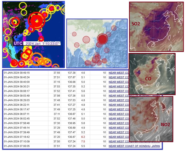
ZetaTalk Insight 8/31/2022: Is
there a nexus between the smoking city streets in Chongqing in
2022 and the howling Dragons in Guizhou Province in
2020? Chongqing is just above Guizhou Province, literally at
the same location. We stated in 2020 that the Dragons were
howling because the mountains there were being pulled apart.
Stretch zones will release Methane. As the rock layers are
pulled apart they release trapped rotting material that
results in Methane gas. Methane is very flammable, like
natural gas, and can burn underground as well as above ground.
Sulfur Dioxide (SO2) accompanies Methane gas because it too is
a component of rotting material. Beyond the
tell-tale rotting egg smell, SO2 emissions can be tracked
by satellites and have for some weeks shown China to be a SO2
hot spot. This does not match the CO2 maps, which show
industrial areas or wild fires or the CO2 emerging from
African rain forests. Thus there is yet another nexus between
the China heat wave and the smoking streets. China is burning
underground.
Elsewhere the stretch of the N American Continent during the New
Madrid Faul Line adjustment continues, with the fault line
unzipping up the lower Mississippi River. The land to the West
of the Mississippi River is sinking and pulled to the SW. The
land to the East likewise sinks as it loses its support. Thus
stretch causes crumbling in Texas, Mississippi State, and
Louisiana.
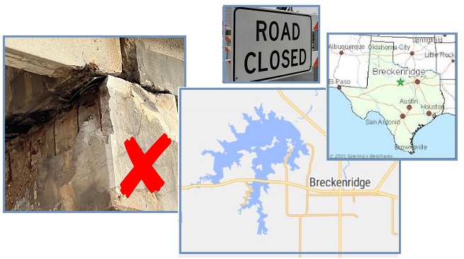
- North Texas' 'Mile Long Bridge'
rapidly Deteriorating, Declared a Disaster
December 24, 2023
https://www.chron.com/news/houston-texas/article/mile-long
- The "Mile Long Bridge," about 140
miles west of Dallas, provides a direct link between the
cities of Breckenridge and Albany. An emergency inspection
revealed significant structural concerns.
- Popular Mississippi Downtown Bridge
Restricted after Inspectors Determine Deterioration on a
Third of its Steel Girders
December 22, 2023
https://www.magnoliastatelive.com/2023/12/22/popular-mississippi
- Bridge safety concerns have
prompted Mississippi officials to restrict a route across
a heavily trafficked downtown route among residents and
tourists. Natchez officials announced that a bridge
on Canal Street would no longer be available to vehicles
weighing more than 5 tons, including tour buses and many
emergency vehicles.
- Belle Chasse Tunnel Permanently
Closed, Project Enters Final Phase
December 21, 2023
https://www.wdsu.com/article/belle-chasse-tunnel-permanently
- The Belle Chasse Tunnel is
permanently closing. It’s the end of an era, built in 1956
the Belle Chasse tunnel, known to locals as the Belle
Chasse car wash because of the constant leaking, is
closing.
ZetaTalk Confirmation
1/1/2024: Why
would Texas wait until the day before Christmas to inspect
this Mile Long Bridge? Because the separation of the Portions
never takes a rest. The slide of the SE Portion to the SE,
being tugged along with Africa during its African Roll, is
relentless. The separation of the Portions has occurred all
along the New Madrid Fault Line except for where it runs
parallel to the upper Seaway, where the burn maps show
non-stop intense ripping - the Montreal scenario about to
happen. Meanwhile the Mainland Portion is not waiting, but is
pulling to the SW as we predicted, dropping the land to the
West of the lower Mississippi River.
As the separation of the Portions continues up along the Seaway,
the Seaway at Montreal began clapping – squeezing shut and then
opening wide. The burn maps showing SO2 Methane and CO from
underground burns show this region to be hot, all the way to the
Seaway exit. Methane bubbles emerged from the Seaway
exit at Clark City on the Quebec shores.

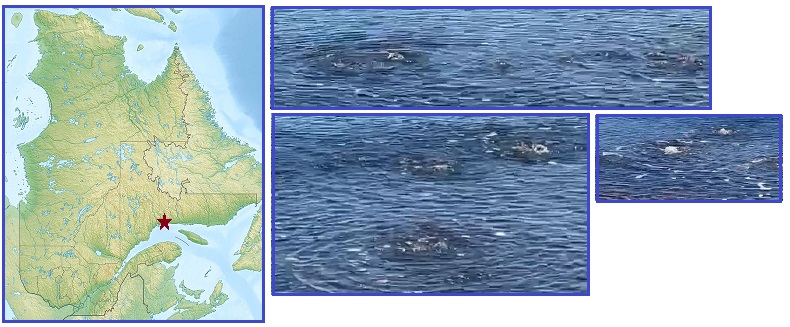
- Vidéo du 28 décembre 2023 - Wow !
Qu'est-ce que c'est que ce phénomène ? Des bulles d'air
qui sortent du sable ? - Clarke City - Côte-Nord (Video
from December 28, 2023 - Wow! What is this phenomenon? Air
bubbles coming out of the sand? - Clarke City - North
Shore)
- Clark City Quebec
https://en.wikipedia.org/wiki/Clarke_City,_Quebec
- Clarke City, called
Paushtik in the Innu language, is a community in the City
of Sept-Îles, in the Quebec region of Côte-Nord. It is
located roughly 20 kilometers west of the Sept-Îles city
centre, on the Sainte-Marguerite River near Route 138.
UFO Warnings
At the start of the ZetaTalk Saga, the Zetas described new land
that would emerge in the S Atlantic due to the Antarctica Plate
pushing up between the tip of S America and S Africa. This
action would take place iteratively, not all at once, so Plate
Movement during the New Madrid Rupture could result in tsunami
waves rushing up against the S American eastern coastline, not
just during the Pole Shift but prior to that time. Such tsunami
could overtop the coastal mountains so the water becomes
temporarily trapped behind these mountains, and is forced to
drain via inland routes.
ZetaTalk Prediction
1999: The
Antarctic plate finds the side abutting the Pacific under
pressure, as the plates due to fold or crumble or subduct in
the Pacific begin to do this. This in effect is forcing the
Antarctic plate to fold itself, like a fan, and it resists
this pressure to fold. The tendency is rather for the
Antarctic plate to break away from these bordering plates, so
it then becomes free to move. Likewise, along the Atlantic,
the spreading plates in the Atlantic are asking the Antarctic
plate to rip apart, which it resists, being a very solid
plate. The point that gives, the weak point, is the border
between the Antarctic plate and those in the Atlantic, as
these are already weakened points. Thus, these weak points
separate, the Atlantic plates going their way, the Antarctic
staying in place. The Antarctic plate is now free on all
sides! The overlapping and compressing plates on the Pacific
side represent pressure and push. The separating and spreading
plates on the Atlantic side represent an opening, so the
Antarctic plate moves in that direction.
ZetaTalk Prediction
2011: Clearly
the Brazilian states of Espirito Santo and Rio de Janeiro will
suffer great trauma during the hour of the pole shift. We have
described excessive tidal waves that will pour up over the
entire coastline facing the south Atlantic, due to new land
emerging when the Antarctic Plate is shoved up
Thus when odd UFO lights began appearing in Parana, near the
border of Argentina and Paraguay, along with similar
UFO lights in other regions of the world expected to
flood, it seemed related. India and Costa Rica also saw these
lights. India of course is expected to be pushed down under the
Himalayas, and Costa Rica as much of Central America likely to
be crushed during Plate Movement.

- We live in Brazil, South America,
in the city of Cascavel, in the west of the state of
Paraná, close to the border of Argentina and Paraguay. For
a week now, every day, five lights have appeared over the
Parque do Iguaçu forest reserve, turning on and off.
Sometimes five light up, one, two or three. They appear
for more than three hours at a time. Are there signs,
warnings or messages?
ZetaTalk Confirmation
1/1/2024: The
Plate Movement process as the 7 of 10 Plate Movements are
coming to an end will include a compressing Pacific and a
widening Atlantic. This is already in process. When the S
Pacific compresses it presses on the Antarctic Plate, pushing
it up between the tip of S America and S Africa. This forces
the Atlantic open, allowing the foot of Africa to slide into
the void created in the S Atlantic. The S American waggle has
also been in process to allow the SE Portion of N America to
slide over the hump of the Caribbean Plate.
What this means for the state
of Parana and other provinces that lie inland along the
coastal mountains of Brazil or within the reach of the Buenos
Aires Bay should it be inundated is that the potential for
flooding exists. The lifting Antarctic Plate will force water
up along these coastal mountains and into the Buenos Aires
Bay. Once inland behind the coastal mountains, this water will
not have an easy route to drain, but might linger. Similar
lights to those in Parana have been seen in Costa Rica and
India, which are also predicted to have sudden flooding due to
Plate Movements. Suddenly gone.
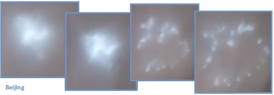
Motherships have been seen hiding in clouds, and UFOs have been
known to visit volcanoes to check their emissions status. Do
they check the status of Petrol
in clouds? Per the Zetas, they do indeed.

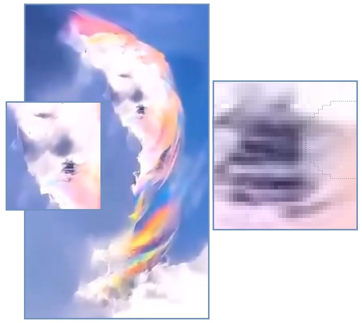
ZetaTalk Confirmation
1/1/2024: This
is a genuine video capture of a Mothership taking a measure of
the Petrol burning process, the concentration of Petrol vs
normal atmosphere presence of chemicals. The swirling and
burning combined made it difficult to cover the mothership
consistently. The Mothership is slightly tilted in the exposed
hole.
New Madrid Jitters
In 2010 when the Zetas laid out their 7 of 10 Plate Movement
predictions, they described large Japan quakes that would herald
the New Madrid Rupture. Then in 2011 when Israel set off the
Fukushima quake to intimidate Japan into cooperating with the
Kazarian Mafia banking system, this confused this situation.
Fukushima was a massive adjustment to that region. Thus quake
swarms in 2018, 2021,
and 2022 were thus questionable. Now
a quake swarm in Japan has occurred in 2023, equivalent in
strength to the Fukushima quakes. Are these the quakes the Zetas
were originally referring to in 2010?
- 2011 Thoku Earthquake and Tsunami
https://en.wikipedia.org/wiki/2011_Thoku_earthquake_and_tsunami#
- On 11 March 2011a magnitude
9.0–9.1 undersea megathrust
earthquake occurred in the Pacific Ocean, 72 km
(45 mi) east of the Oshika Peninsula of
the T?hoku region. It lasted approximately six
minutes, causing a tsunami. It is sometimes known in
Japan as the "Great East Japan Earthquake". It was
the most powerful earthquake ever recorded in Japan,
and the fourth most powerful earthquake recorded in
the world since modern seismography began in 1900.
ZetaTalk 2010
Prediction: These
quakes will rival the large quakes that Japan has historically
suffered periodically, but will be characterized by
sympathetic adjustments in the Pacific Ring of Fire not
normally accompanying large Japan quakes. The whole region
will be seen as under pressure from subducting Pacific plates
and the reaction to this pressure. It is the pressure from the
Pacific that is the issue, as the Pacific is compressing.
Likewise, the Philippine Plate is at issue, as it loses in the
compression game and in essence is pushed under and lost.
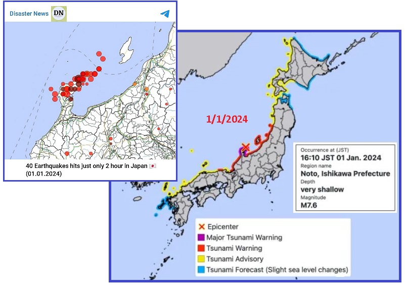
- Massive Earthquake hits Western Japan,
Triggering Tsunami Warnings
January 1, 2024
https://www.cnn.com/2024/01/01/asia/japan-earthquake-tsunami
- It was the first major tsunami
warning to be issued since 2011. The Japan Meteorological
Agency immediately issued a tsunami warning along coastal
regions of western Japan, and the first waves were
reported hitting the coast just over 10 minutes later.
The quake swarm in Japan was so powerful that it rearranged the
coastline, lifting the coast by 4 meters (12 feet) around
Minazuki Bay.
- Space Photos show Japan's
7.6-Magnitude Earthquake Lifted Land out of the Sea,
Extending parts of its Coastline by as much as 2 Football
Fields
January 6, 2024
https://www.msn.com/en-us/news/world/space-photos-show-japan-s-7-6-magnitude
- Japan's Noto Peninsula has newly
exposed beaches due to the earthquake that struck Monday.
The quake raised land along the coast, extending
the coastline by up to 820 feet in some places.
- Changes in the Coastline Associated
with the 2020 Noto Peninsula Earthquake Based on Analysis of
Observation Data from Daichi-2
January 4, 2024
https://www.gsi.go.jp/uchusokuchi/20240101noto_pwr
- Some areas along the coast of
areas where uplift associated with the
earthquake was detected have become landlocked.
Around Minazuki Bay in Wajima City, where an uplift of
approximately 4 meters was detected, changes in the
coastline of approximately 200 meters can be seen.
ZetaTalk Confirmation
1/1/2024: In
2010 when we laid out the 10 Steps of the
7 of 10 Plate Movements, the Japan quakes were Step 8,
the New Madrid was Step 9 and the Azores rip Step 10. Since
that prediction in 2010 the Khazarian Mafia under Bibi’s
direction caused the massive Fukushima
disaster on March 11, 2011, altering
the course of the sequence of events preceding the New
Madrid Rupture. In 2012 the Council of World slowed the New
Madrid process down with Humming
Boxes and Monoliths. In
2018 there was another Japan quake swarm and indeed the
New Madrid unzipping process started on October
19, 2019 in New Orleans.
Now we have another massive
quake swarm in Japan on New Years Day, generating tsunami
warnings not issued since 2011 during the Fukushima disaster.
The magnitude of this swarm meets our original prediction,
given that the USGS has now downgraded large quakes by a
magnitude 3.2. On this New Years Day China is having quakes
ripping up its central China Wudu-Mabian
fault line where we predicted the China adjustment would
emerge, and Beijing has been ready for this adjustment for
months. The triangle of countries in the Asian
UFO display are active. Africa has been rolling
with the SE Portion of N America pulling to the SE, and
clapping has even begun in the Seaway at Montreal. The stage
is set.
Fukushima may have changed the
dynamics in the Pacific by easing tensions in the Pacific, and
the Council of Worlds certainly deliberately slowed the New
Madrid scenarios down, but the factors we used when laying out
the 7 of 10 scenario still exist. The Pacific Plates must
overlap and compress to the extent that the Mainland Portion
shifts to the SW sufficiently to trigger the New Madrid
Rupture. This must move in concert with the tenuous hold the
SE Portion has on the N Atlantic, where it clings to the
Mainland along the ridge between the mouth of the Seaway to
the Azores.
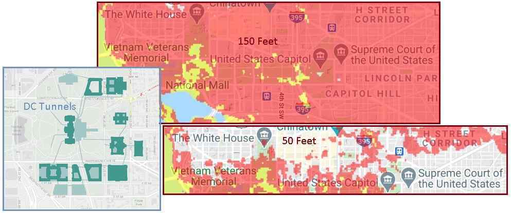
Given all the signs that the New Madrid Fault Line is in the
process of completing the separation of the Portions, and allowing
a massive tsunami to emerge from a void at the Azores, is there
any surprise that a tsunami warning was sounded at 4:00 am in DC
on December 30? This was quickly cancelled, but not before it went
viral on social media. The Zetas had predicted that Washington DC
could get up to a 150 foot wave, due to tidal bore.
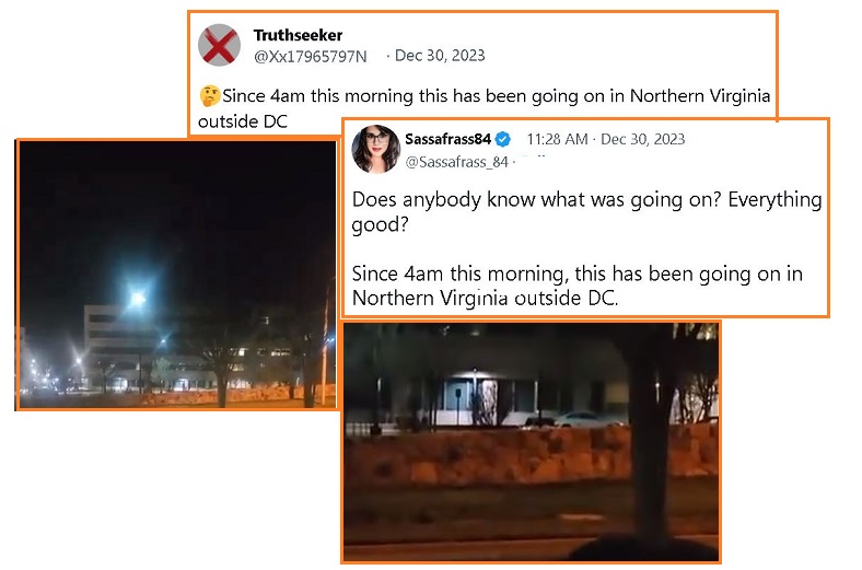
- Northern Virginia: "THIS IS ONLY A
TEST. THERE IS NO EMERGENCY AT THIS TIME."
Dec 30, 2023
https://www.youtube.com/watch?v=OgfQsSu7SL4
- Blasting from outdoor speaker for
2 hours.
ZetaTalk Confirmation
1/1/2024: The
Junta has a dilemma. They know the N America Plate is
splitting along the New Madrid Fault Line with a large portion
– the SE Portion – destined to travel with Africa during its
roll. This will, according to our predictions and the
1811-1812 history, create devastation in many states along the
Mississippi River. Given the ZetaTalk accuracy on predictions,
the Junta is also taking our warnings about a 50
foot tsunami rushing against the US East Coast with a
tidal bore up against Washington DC.
Given the tinkering the
Council of Worlds has inserted into the timing of the New
Madrid Rupture - which is now at least 2 years late beyond our
original predictions due to the Council slowing the
timeline down - the Junta does not want to impose Martial Law
preemptively. But the Junta knows from their own geological
and ocean oceanography experts that our sequence of events is
highly likely to occur. The New Madrid Fault Line separation
of the Portions has reached Montreal, where the Seaway has
begun to clap. This was another of our predictions.
In the week before Christmas
the buoys on the Seaway gave evidence of the Seaway repeatedly
being squeezed and then opening wide. The water level rose
during a squeeze and then dropped when the Seaway parted. Our
prediction, when doing a UFO display interpretation, was that
the Seaway would open wide when the SE Portion slides to the
East, but then the Azores would rip open allowing the Seaway
to return to its previous state. That would be the moment when
the tsunamis occur. EBS alerts are occurring, which are later
called tests. Tests do not occur at 4:00 am.
|